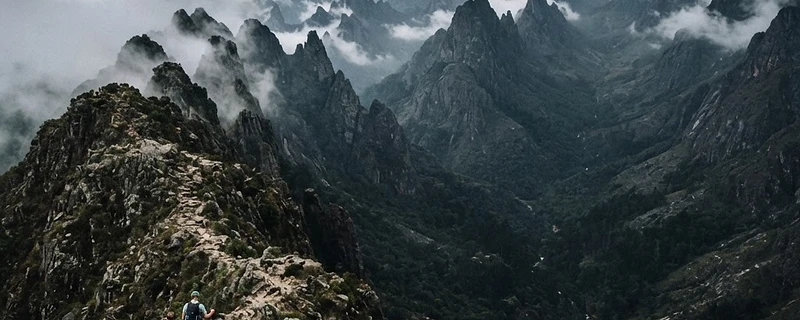
The Chimanimani Mountains straddle the Mozambique-Zimbabwe border, harboring endemic species found nowhere else on Earth. Discover a transboundary conservation wonder.
Mountains Between Two Worlds
Rising sharply from the Mozambican plain in Manica province, the Chimanimani Mountains form a dramatic skyline of quartzite peaks, deep gorges, and mist-forested valleys that straddle the border between Mozambique and Zimbabwe. They are among the oldest mountains on Earth — their quartzite ridges date back over 2 billion years — and they harbour life found nowhere else on the planet.
This is not a place of gentle slopes and manicured trails. Chimanimani is raw, rugged, and remote. The trails are footpaths worn by generations of local people. The peaks rise to 2,436 metres at Mount Binga — Mozambique's highest point. The forests contain species that scientists are still discovering.
A Biodiversity Hotspot
The Chimanimani Mountains are recognized as one of the most important biodiversity hotspots in southern Africa:
- Endemic plants: Over 100 plant species found nowhere else on Earth, including rare proteas, orchids, and succulents that cling to cliff faces.
- Bird species: The Chimanimani is home to specials like the Swynerton's Robin-Chat, the Chirinda Apalis, and the endangered Blue Swallow, which nests in montane grasslands.
- Amphibians and reptiles: Several endemic frogs and lizards, including species discovered as recently as the 2010s.
- Mammals: Leopards, bushbucks, and rare small mammals in the forest patches.
- Freshwater: Crystal-clear mountain streams host endemic fish species.
The reason for this extraordinary biodiversity is isolation. The Chimanimani's quartzite peaks create "sky islands" — isolated habitats where species evolve independently, producing unique forms that exist nowhere else.
Two Countries, One Mountain
The mountains are split by an international border, but nature does not recognise it. Elephants once migrated across these peaks. Birds nest on the Zimbabwean side and feed on the Mozambican side. Water flows from Chimanimani's peaks into both nations' river systems.
Recognizing this, both countries have established protected areas: Chimanimani National Park in Zimbabwe (established 1949) and the Chimanimani Transfrontier Conservation Area in Mozambique (formalized in recent years). Together, they form one of southern Africa's most important transboundary conservation areas.
Hiking the Mozambican Side
The Mozambican side of Chimanimani is far less developed than the Zimbabwean side — and that is its charm. There are no hotels, no cable cars, no curio shops. There are mountains, forests, rivers, and community guides who know every path.
Mount Binga
At 2,436 metres, Binga is Mozambique's highest peak. The ascent takes 2–3 days, starting from the community of Muhanga. The trail passes through montane forest, open grassland, and finally bare quartzite rock. On a clear day, the view extends across the Mozambican plain to the Indian Ocean.
The Mussapa Pequena Valley
A stunning U-shaped glacial valley — yes, glaciated during the Permian ice age, 300 million years ago — with a crystal river running through it. The valley is flanked by sheer quartzite cliffs.
Cave Paintings
The mountains contain ancient rock art sites, evidence of human habitation dating back thousands of years. The San people and their ancestors left paintings of animals, hunts, and spiritual symbols.
Birding Hotspots
The mossy forests above 1,500 metres are birding paradise. Local guides — trained through community conservation programmes — can lead you to see species that most birders spend years chasing.
Community Conservation
The future of Chimanimani depends on its communities. In the Mozambican highlands, several villages sit at the mountains' base, and their involvement is essential:
- Community guides: Local people trained as mountain guides, earning income from hikers.
- Conservation agriculture: Programmes teaching sustainable farming that doesn't require clearing montane forest.
- Fire management: Community-led controlled burning to prevent destructive wildfires.
- Ecotourism: Small-scale, community-owned campsites and homestays.
CAST Mozambique (Community & Sustainable Tourism), listed on nendeni.com with a 90% community benefit rate, works in the Manica highlands to build exactly this kind of community-led tourism economy.
How to Visit
- Access: From Chimoio (Manica's capital), drive to Muhanga or Rotanda — about 3–4 hours on rough roads. A 4x4 is essential.
- Best season: June to August (coldest, driest — best hiking conditions). Avoid November–March (rains, leeches, mud).
- What to bring: Hiking boots, warm layers (nights drop below 5°C at altitude), rain gear, water purification, tent.
- Guides: Essential — trails are unmarked. Hire through CAST or local community associations.
A Mountain That Belongs to Everyone
Chimanimani is not a park with an entrance gate and a ticket office. It is a living landscape — mountains, forests, rivers, and people, shared between two nations and belonging to all of them. To hike here is to step into a world that has changed little in thousands of years, where every rock and plant tells a story older than human memory.
It is one of the last wild places in southern Africa. And it is waiting.
Find community tourism programmes and ethical hiking experiences in Manica at nendeni.com.